Finding Your Way in the Country
Country residential properties are generally defined as residential properties on private well and septic systems and outside of a village or town boundary.
Acreages can be in subdivisions from a piece of larger land or lots in a multi-lot subdivision, the defining difference is the location and services.
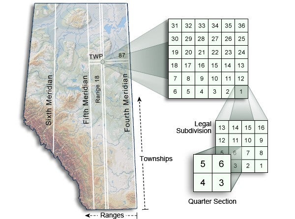
The ATS (Alberta Township Survey System) designates land as being west of the 4th Meridian (110 degrees west longitude), 5th Meridian (114 degrees west longitude) or 6th Meridian (118 degrees west longitude). Between meridians are a series of columns, each six miles wide, called ranges. They are numbered consecutively from east to west, beginning west of the meridian. Townships are also six miles wide and are numbered from south to north. The southern Alberta border with Montana is township 1, up to the northern border with the Northwest Territories at township 126. Parcels of rural land in Alberta are defined by their size as townships (23,040 acres - 6 miles x 6 miles), sections (640 acres - 1-mile x 1-mile) and quarter sections (160 acres – ½ mile x ½ mile).

The rural address pinpoints access to the property from a range road, which runs north-south, or a township road, which runs east-west. Township roads are numbered using the township number, the first road is 0 (zero) with increments increasing every 1 mi (1.6 km). Township 51's first township road would, therefore, be numbered 510, its second township road (2 miles north) is numbered 512, etc. Range roads are numbered from the east boundary of the range, and increase as one moves west in a similar fashion. Range 21's first range road would, therefore, be numbered 210, its second numbered 211, etc.
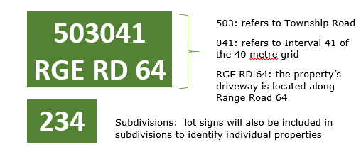
The property address is the access location onto a Township or Range Road. Each mile is divided in 40 units that are 132 ft (40 m) wide. These units are odd-numbered from 1 to 79 on the south side of township roads and on the east side of range roads. The opposite side of the roads are even-numbered 2 to 80.
An example address of a property on Township Road 512, 1,320 ft (400 m) east of the intersection with Range Road 211, would be 21133 Township Road 512. Multi-lot subdivisions are addressed similar to apartments in a city, with a street address and a unit number.

There are some key differences between a residence on an acreage and a residence in a municipality. The most important are wells, septic systems, power and natural gas. All services such as power, natural gas, water, sewer, cable, telephone and internet in a rural setting are more expensive because they are more difficult to provide and there are longer distances between the users.
Country residential properties are generally defined as residential properties on private well and septic systems and outside of a village or town boundary.
Acreages can be in subdivisions from a piece of larger land or lots in a multi-lot subdivision, the defining difference is the location and services.
The ATS (Alberta Township Survey System) designates land as being west of the 4th Meridian (110 degrees west longitude), 5th Meridian (114 degrees west longitude) or 6th Meridian (118 degrees west longitude). Between meridians are a series of columns, each six miles wide, called ranges. They are numbered consecutively from east to west, beginning west of the meridian. Townships are also six miles wide and are numbered from south to north. The southern Alberta border with Montana is township 1, up to the northern border with the Northwest Territories at township 126. Parcels of rural land in Alberta are defined by their size as townships (23,040 acres - 6 miles x 6 miles), sections (640 acres - 1-mile x 1-mile) and quarter sections (160 acres – ½ mile x ½ mile).

The rural address pinpoints access to the property from a range road, which runs north-south, or a township road, which runs east-west. Township roads are numbered using the township number, the first road is 0 (zero) with increments increasing every 1 mi (1.6 km). Township 51's first township road would, therefore, be numbered 510, its second township road (2 miles north) is numbered 512, etc. Range roads are numbered from the east boundary of the range, and increase as one moves west in a similar fashion. Range 21's first range road would, therefore, be numbered 210, its second numbered 211, etc.
The property address is the access location onto a Township or Range Road. Each mile is divided in 40 units that are 132 ft (40 m) wide. These units are odd-numbered from 1 to 79 on the south side of township roads and on the east side of range roads. The opposite side of the roads are even-numbered 2 to 80.
An example address of a property on Township Road 512, 1,320 ft (400 m) east of the intersection with Range Road 211, would be 21133 Township Road 512. Multi-lot subdivisions are addressed similar to apartments in a city, with a street address and a unit number.

There are some key differences between a residence on an acreage and a residence in a municipality. The most important are wells, septic systems, power and natural gas. All services such as power, natural gas, water, sewer, cable, telephone and internet in a rural setting are more expensive because they are more difficult to provide and there are longer distances between the users.

